- Asia Report !!
China and the Silk Road - Modern History of the Silk Road
A Chronology of the Silk Road
Estimated 500 BC - 14Th Century Emergence Maritime Trading Routes
This page was last updated on: February 19, 2019

This page was last updated on: February 19, 2019
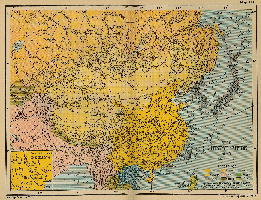
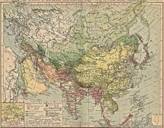
China Report - Historic Map - China (Qing) Empire in 1910 AD
An obviously non-Chinese but western-made Map of the
Qing Dynasty
Chinese Empire in the year 1910 AD, a year in which China's sovereignty has been under threat and siege for over 70 years.
In this Map of 1910 AD, made one year before the abdication of Last Ching Emperor Xuan Tung (a.k.a.Aisin-Gioro Pu Yi) and the final end of China's Feudal History, China is depicted as in its smallest boundaries and definition. Most notably Manchuria, and Inner Mongolia, both territories nominally under Chinese Control and under Chinese Sovereignty are depicted as separate area's.
Other interesting features of the Map and geography of the Time : after the Sino-Japanese war of 1899 AD, both Korea and the Island of Formosa (now Taiwan / ROC) have been annexed by the Japanese Empire.

1865 - 1874 AD : The "Dungang" Islamic revolts (or Hui Minorities' War, or the Muslim Rebellion) once more temporarily turned Hotan into independent Muslim hands (a time during which the Mogao Caves at Dunhuang were vandalized!). A few years thereafter Hotan briefly became part of the short-lived state known as East Turkestan.
In 1865, while the Dungang Islamic Revolts were ongoing in what today is the Xinjiang-Uyghur Autonomous Region of the Peoples Republic of China (P.R.C.), in Himalayan Territories of north India, the firs steps were made in what later has been dubbed "the Great Game" for Central Asia. In that year,
-----> History of the Silk Road :

See Also - The
Han Dynasty
and the
Tang Dynasty
history.

Silk Road (8) Modern History of the Silk Road I : 1800 A.D. to 1900 Re-discovery of the Silk Road
Mohammed-I-Hameed, a Native Indian but British Agent for the first time succeeded in completing and mapping a road between northern India and the territories around the Taklamakan Desert which today are part of the Xinjiang-Uyghur Autonomous Region. The mission to send a native Indian to explore the wild lands beyond the India that was already known and controlled by the British Empire, had been conceived of as early as in 1866, when one Captain Montgomerie who worked with the (Grand) Survey of India had noted that natives of the Ladakh Region (in Kashmir) traveled more ore less freely across the high passes to meet up with the main route of the silk road at Kashgar, Yarkand or Hotan .
In the period between June 12 of 1863 and roughly the last week of September in 1863, Mohammed-I-Shameed traveled via Kashmir to the Ladakh Region, from there passing by Camel caravan northwards across the Karakoram mountain range to Yarkand (today a part of Kashgar City Prefecture ). He subsequently lived in Yarkand for some 6 months until March of 1864 when authorities had become suspicious and the secret spying expedition had to make its quiet leave. Although Mohammed-I-Hameed died of illness in sight of home, all notes, measurements and reports gathered by him were received by British authorities providing them for the first time with invaluable geographic information, but also with rumors of buried ancient treasures to be found in lost cities out in the Taklamakan Desert.
February 19, 1865 AD: Birth of Sven Hedin in Stockholm, Sweden. Later in life Hedin would become one of the leading silk road explorers and experts of his Era.
June 25, 1865: The CIM, China Inland Mission, a Christian Missionary organization which aims to spread Christianity across the poor inland Provinces of China, is established in Brighton Beach, Sussex, England. Although ultimately the proselytizing efforts in territories along the Silk Road will not form the bulk of the activities of the organization, members of the CIM will make their mark on the history of the Silk Road in China.
In May of 1866 the first party of Christian missionaries sailed for China. A first mission and headquarters was established in Hangzhou , Zhejiang Province in 1866 by John Hudson, one of the front runners of the movement.
1829 AD: The German Geographer and Explorer Alexander von Humboldt embarks on an expedition on the Silk Road. It is a Russian sponsored mission to chart the Western Sides of the Altai Mountain Range which today separates Xinjiang-Uyghur Autonomous Region of China from the nations of Kyrgyzstan and Uzbekistan .
Von Humboldt did write an official report for the Russian Government on his findings during the journey to the Chinese Border Regions, however -possibly due to the sensitivity of his Mission- he refused to divulge or write any personal accounts of it.
1834 AD: Chinese Government declares its citizenry now numbers over 400 million, a growth of 60 million in the 22 years since the 1812 year National census.
meeting there with George Nathaniel Curzon, England's then Viceroy to India.
This expedition resulted in 1,149 pages of maps, on which Hedin depicted newly discovered lands. He was the first to describe yardang (landscape) formations in the Lop Desert.
1899 AD Loulan rediscovered by Svedish Explorer Sven Hedin, after being lost to history for a 1000 years. (Further discoveries at Loulan were made later by Hungarian Marc Aurel Stein in 1914 AD).
When Hedin reaches Lop Nor it has recently filled with water after a period of long droughts ended. Hedin navigated the Yarkand, Tarim and Kaidu rivers and found the dry riverbed of the Kum-darja as well as the dried out lake bed of Lop Nur. Near Lop Nur, he discovered the ruins of the 340 by 310 metres (1,120 by 1,020 ft) former walled royal city and later Chinese garrison town of Loulan, containing the brick building of the Chinese military commander, a stupa, and 19 dwellings built of poplar wood. He also found a wooden wheel from a horse-drawn cart (called an arabas) as well as several hundred documents written on wood, paper and silk in the Kharosthi script. These provided information about the history of the beforehand but mythical lost Buddhist Kingdom and city of Loulan, which, among things according to the histories of the famed Han Dynasty historian Sima Qian) had once been located on the shores of Lop Nur but had been abandoned around the year 330 CE because the lake had dried out, depriving the inhabitants of drinking water.
Asia Report - Map Roads & highways in Central Asian Nations
A geographical and topographical overview Map of the Central Asian Nations of (South) Kazakhstan, Tajikistan, Kyrgyzstan, Uzbekistan, Turkmenistan, and Parts of North Iran, North Afghanistan, North Pakistan, North India (Jammu & Kashmir), and the region of Kashgar (Kashi) in West China's
Xinjiang-Uyghur Autonomous Region of China.
Map includes International Borders, national provinces and regions (where possible), main cities and roads, main lakes and waters, as well as the locations of Historic Sites, wildlife reserves, officially designated ethnic autonomous communities, main mountain peaks with heights and more coming soon !
Browse the Map, click and follow the links to additional information on each site and location. Click on selected highlighted Map sections for a more detailed map of that Region. Explore the connections in central Asia as never before !

Find DrBen and ChinaReport on Facebook with the latest from www.drben.net.


/asiareport/images/image-ID-ad8912cc-3f9e-4a73-9bcd-0a4de8e2fbd0.jpeg)
Tibet, Tibetan Plateaux, Regions + disputed borders
- Geographic Overview Map 1A
A geographic overview Map of Tibet, the Tibetan Plateaux and relevant adjoining regions and territories. Map includes a large part of Xinjiang Uyghur Autonomous Region (PRC), Kashmir, North-West Pakistan, Northern India, Nepal, Bhutan, Bangladesh and the culturally associated region of Myanmar (Burma). A small part of Yunnan Province of China is also depicted.
This Map clearly defines disputed borders and territories, Nations (except for Tibet), Provinces and Regions, as well as geographical features such as main mountain ranges, main rivers & lakes of the region, basins and plains, plus the locations and names of main cities, towns, monuments and landmarks.
Browse the Map and follow the Links where available to access more maps, information and photos on each location and landmark.

A year after Mohammed-I-Hammed completed his mission, in 1866, the first westerner managed to make his way across the Indian Himalayas from Leh in Ladakh via a previously unidentified pass which led through the Aksai Chin Region northward to Hotan along the silk road in the Taklamakan Desert. Helped by an unexpected invitation from the local Khan Badsha to stay for a few days (later Sir) William Johnson, the man who one earlier had helped investigate the cause of death of Mohammed-I-Shameed, traveled to Hotan where he mainly gathered political and military information. During his brief stay Johnson was however able to further confirm the rumor of the existence of ancient buried cities in the sands. As he reported, ancient tea bricks, reportedly found out in the desert, were regularly on sale at the local bazaar(s) where they were outright popular especially since the ongoing rebellions and battles in the Xinjiang Region had disrupted the usual supply lines running via Mongolia and what was by then Russian held territories.
With this feat and new by-road of the Silk Road, a shortcut between Hotan and India bypassing the Karakoram Range had been re-discovered (for the International Western world, of course locals knew of its existence).
(For more details refer to: History of Hotan and Prefecture ).
In 1868, the Buchara Emirate lost a war with Imperial Russia, which had colonial aspirations in the region. Russia annexed much of the emirate's territory, including the important city of Samarkand (in current day Uzbekistan ).
In the aftermath, in 1869, the Samarkand Kufic Kuran (Uthman Quran, Samarkand codex, Samarkand manuscript and Tashkent Quran), an 8th or 9th century religious document taken to be the oldest surviving Kuran text in the world, was taken from Khoja Ahrar Mosque of Samarkand when the Russian general Abramov bought it from the Mullahs of that Mosque and gave it to Konstantin von Kaufman, Governor-General of Turkestan, who subsequently sent the important historic document (book) to the designated Russian Imperial Institute for study of foreign and antique documents, texts and artifacts, which was the Imperial Library in Saint Petersburg (now the Russian National Library. Once in Saint Petersburg the document attracted the attention of Orientalists and eventually a facsimile edition was published in Saint Petersburg in 1905. The 50 copies soon became rarities. The first thorough description and dating of the manuscript was undertaken by the Russian Orientalist Shebunin in 1891.
1869: Manchu Qing Military Forces begin a long but successful campaign of reconquest of territories lost in the Dzungar Islamic Rebellion led by Yakub Beg. The Rebellion has spread from western Xinjiang along the pathways of the silk road into the Hexi Corridor of Gansu Province and the rebellious forces demand succession (independence and regional autonomy). A military response is the traditional answer.
While the military campaign evolves, official Government military arsenals are established in the cities of Xian and Fuzhou (the former end or start point of the Silk Road in China, the latter location a major port of the maritime silk road, location of the Naval Shipyard as well as the Naval Academy).
1870 AD: Russian military forces invade and take control of large parts of the Valley if the Ili River in the north and central west of Chinese Turkestan (aka Xinjiang). The occupation would hold until a Chinese-Russian land and money swap arrangement in 1881. Meanwhile, the Ili River Valley would serve as a Russian intelligence base and stop over for Russian Expeditions in the nearby mountainous regions and the larger Chinese Turkestan Regions.
1870 AD: In the wake of fresh Russian military conquests in Central Asia, Russian explorer Nikola Prejalevski made the first of his total of four major trips through Central Asia (1870 AD - 1885 AD). One of his greater achievements was the mapping of the Lop Nor Desert in the eastern expanses of the Taklamakan Desert in Xinjiang or Chinese Turkestan.
1871: The Fifth Great Buddhist Council (of the world) meets in Mandalay (royal Capital of Burma (Today: Myanmar). The council introduced a new authorized text of the Buddhist Canon, the Tipitaka.
1872 AD: Manchu Forces under command of General Zuo-Zong Tang besieged the famous silk road town of Suzhou (Jiuquan) situated just within the Great Wall of China (in current day Gansu Province). With the city taken from rebellious Dzungars nominally led by Yakub Beg (in west Xinjiang), the Manchu Armies are ready to start their advance westward towards Xinjiang, taking back territory along the way.
1872/73 AD: Buchara Khanate (Persian: خانات بخارا ; Uzbek: Buxoro Xonligi), since 1775 the Buchara Emirate becomes a Russian Protectorate and thus a part of the expanding Russian Empire in East-Asia. It will last as an administrative entity until the year 1920 but is soon factually surrounded by the newly created Russian Protectorate (Province) of Russian Turkestan (Русский Туркестан) which included current day Uzbekistan , Tajikistan , Kyrgyzstan and parts of Kazakhstan .
1873: After several earlier failed attempts, Russian armed forces take the city of Khiva former capital of Khwarezmia and the Khanate of Khiva (Uzbek: Xiva ; Persian: خیوه ; Russian: Хива) (in current day southern Uzbekistan) finally breaking the resistance of the Khanate of Khiva. Its territories much reduced, the Khiva Khanate becomes a Russian Protectorate.
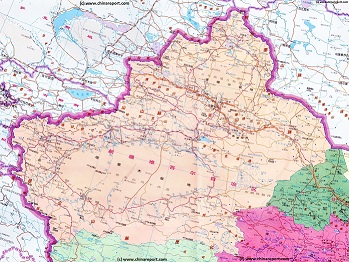
Xinjiang Autonomous Region Geographic Map 1A
A Geographic overview Map of the entire Xinjiang-Uygur Autonomous Region and large parts of neighboring Nations of India, Pakistan, Afghanistan, Tajikistan, Kyrgyzstan and Kazakhstan, The Republic of Mongolia, as well as bordering Chinese Provinces and Territories of Inner-Mongolia AR, Gansu Province, Qinghai Province and Tibet Autonomous Region. This Map Includes Cities and Towns (shown by size), Main Monuments & landmarks of Xinjiang AR, the Taklamakan Desert in South-Central Xinjiang AR, major highways, provincial railroads, a variety of border passes in the Karakoram Mountain Range and the Tian Shan Mt. Range, plus main mountains, waterways, rivers and lakes of this large region.
1890's/ 1900 AD: At the highpoint of the Colonial Era, European Silk Road explorers Sven Hedin and later Sir Marcus Aurel Stein explore the Silk Road paths of Central Asia . Hedin survives the sands of the Taklamakan Desert to refind the Lost Civilization of Khotan . In 1900 AD Stein makes excavations of the Khotan Site.
1889-90: Captain Hamilton Bower and Expedition explore the Northern Rim of the Taklamakan Desert, ostensibly on a mission pursuing the murderer of Andrew Dalgleish, a Scottish born trader who had been murdered in the previous year (1888) while making his way through the notorious passes between Leh in Ladakh (today Kashmir, India) and Yarkand in Xinjiang but also on a secret mission under orders of the British Government of India.
During their exploits the expedition visited Kucha (today a County in the east of Aksu City Prefecture ). The expedition brings back scriptures written on birch bark in an Indian Language. Today the document is famous as the Bower Manuscript which after deciphering revealed to be an originally Tocharian text written in the Sanskrit language but making use of the Brahmi Alphabet. The document confirmed earlier rumors of existence of Lost Buddhist Kingdoms in the great East Turkestan (Chinese Turkestan) Regions, which previously had been thought to be exclusively Islamic in origins.
Although wild rumors had been circulating in prior decades, the recovery of this valued and still rather unique documents is said to have started in earnest the race for exploration and archeological discovery in Central Asia (and along the Silk Road) which flourished and topped in the early 20th century.
1892 AD: A French expedition under leadership of Dutreuil de Rhins explores the southern rim of the Taklamakan Desert and later Tibet , where the expedition leader is murdered.
1893-94: Archeologist Ernest Chantre opened the first few trial trenches at the village then called Boğazköy, today better known as Ḫattuša, the ruined and abandoned Capital of the Bronze Age Hittite Empire (Estimated c. 1600 BC–c. 1178 BC), which encompassed large parts of current day Egypt, the Levant, Syria, Mesopotamia ( Iraq ), Turkey (Asia Minor) as well as southern Greece. It is the first of many such archeological missions.
1893 AD - 1897: Later world renowned Swedish Explorer and geographer Sven Hedin makes
The first of his great journeys and explorations into Central Asia.
1894/1895 He makes several attempts to climb the famous Muztagh Ata Peak in the (Eastern) Pamir Mountain Range, before heading to Kashgar to prepare his expedition into the Taklamakan Desert.
In January 1896, after a stopover in Kashgar, Hedin visited the 1,500-year-old abandoned cities of Dandan Oilik and Kara Dung, which are located northeast of Khotan in the Taklamakan Desert. Although his first attempted expedition through the sands of the Taklamakan Desert between the Yurunkash and Hotan Rivers nearly left him dead in the Desert, regardless afterwards, the expeditions continued.
At the beginning of March 1896, Hedin discovered Lake Bosten, one of the largest inland bodies of water in Central Asia. He reported that this lake is supplied by a single mighty feeder stream, the Kaidu River. He mapped Lake Kara-Koshun and returned on 27 May to Khotan. On 29 June, he started out from there with his caravan across northern Tibet and China to Beijing , where he arrived on 2 March 1897. He returned to Stockholm via Mongolia and Russia.
At the end of his journey Hedin is the first to have explored the western rim of the Taklamakan Desert, taking away to foreign countries hundreds of historic objects recovered from ruined and lost Oasis towns in the Taklamakan Desert. His finds further ignite the western strife for recovery of ancient archeological treasures from the Silk Road in Central Asia.
1895: Eva (Evangelina) French arrives in China to work with the China Inland Mission (CIM). In the coming two decades she will explore along the Silk Road in Gansu Province and the current day Xinjiang-Uyghur Autonomous Region , spreading the gospel and co-authoring a book about these uncommon adventures which today is best known under the title "The Gobi Desert - the adventures of three women traveling across the Gobi Desert in the 1920's".
1898: A German team of archeologists for the first time starts exploration of the historic Ruins of Aššur (Akkadian; Syriac: ܐܫܘܪ 'Āshūr; Persian: آشور : Āshūr; Hebrew: אַשּׁוּר Aššûr, Arabic: اشور : Āshūr ; Kurdish: Asûr), also known as Ashur and Qal'at Sherqat, in ancient history the Capital of the Old Assyrian Empire (2025–1750 BC), the Middle Assyrian Empire (1365–1050 BC), and for a time, the Neo-Assyrian Empire (911–608 BC), situated on the banks of the Tigris River in Saladin Governate of Iraq . In the year 1900 A.D. the first archeological excavations led by Friedrich Delitzsch start.
1898 to 1900 AD: Bliss and Macalister for the first time in history undertake archeological surveys and excavations at Mareshra, an ancient now ruined historic site of the Tribe of Judah (שבט יְהוּדָה), one of the supposed 12 historical tribes of the confederate Jewish state of Judah (שבטי ישראל) in the 2nd millenium B.C. They uncover a planned and fortified Hellenistic city encircled by a town wall with towers. Two Hellenistic and one Israelite stratum were identified by them on the mound. Many of the ancient city's olive presses, columbaria and water cisterns can still be seen.
November 1, 1898: Emperor Wilhelm II of Germany passes through the by then already famous town of Baalbek in Lebanon on his way to the holy city of Jerusalem. Noting the dilapidated conditions of the Baalbek roman ruins site and the presence of a village, there - when able to do so- he takes swift action. Within a month a first German archeological team arrives at the location to start archeological excavations which, with intervals, will last into the year 1904. Although no shocking or spectacular finds are made, the archeological team is certain to be able to date the origins of the Baalbek site as previous to the construction of Roman Temples there.
1870 - 1873: Sir Douglas Forsyth, a British Civil Servant in the Punjab Region and an authority on Central Asia led a British Mission to Yarkand with the aim of befriending the local Tajik Warlord Yaqub Beg (محمد یعقوب بیگ), who at the time had control of large parts of the current day Xinjiang-Uyghur Autonomous Region. The mission was a failure as Yaqub Beg was away from his Capital. In 1873 a fresh and larger expedition was sent from India to Yarkand and Kashgar, once more with aim of contacting and befriending the local Warlord Yaqub Beg. On his second mission Sir Douglas Forsyth was much more succesful and certain agreements were reached between the Tajik, Uighur and Kyrgyz in Xinjiang and the British on countering any possible Russian military expansion in the Xinjiang Area.
During the mission the British participants also learned more about the supposed ruined and lost cities that were to be found in the Taklamakan Desert. While the British were busy with their politics in Yarkand, opportunity was found to send out two local servants eastward to Hotan with the mission to find out anything they could about the reported lost and ruined silk road cities to be found near Hotan and Yurumkash. For the first time objects recovered from such sites are brought back. Among these are two figurines recovered from lost ruins near Keriya (Mugala) , one a 10th century Buddha figure, the other a statue of the Monkey-God (Hunooman). Other objects recovered elsewhere included gold rings, nose rings and coins of Greek and later Kingdoms founded along the Silk Road in the 3rd century BC and afterwards (To be more exact: one iron coin of Hermeus the last Greek King of Bactria and coins of Constans II, King Pognatus, Justinus and Antimachus and Theodosius of the Greco-Bactrian Kingdom (250 BC-125 BC)).
January 1801 AD: A Russian army consisting of infantry and cavalry was sent via the (frontier) fortress of Orenburg toward Khiva (dubbed the "Indian March of Paul) but was recalled while south of the Aral Sea when Tzar Paul I (Russian: Па́вел I Петро́вич; Pavel Petrovich)(Life: 1 October, 1754 - 23 March, 1801)(Reign: 1796 AD - 1801 AD) was murdered in March 1801 (Pahlen plot).
22 August, 1812: Swiss traveler Johann Ludwig (Burckhardt) (Life: 24 November 1784 - 15 October 1817) " discovers " and is the first European who describes the ancient Nabatean city of Petra (in Trans-Jordania, today the Kingdom of Jordan), one of the wonder of the western Silk Road. It is the beginning of a long foreign romance with this particular silk road site.
18 July 1814: Johann Ludwig, Swiss Traveler extra-ordinaire, arrives in Jeddah in Arabia (today: Saudi Arabia), and after proving himself of his Muslim credentials is allowed to travel on to the Holy City of Mecca, where among things he engaged in the rituals of the (yearly) Hajj. During his stay of several months in Mecca, an unheard of thing for a European, Ludwig made detailed observations and some surveys of the holy City, leaving details for later travelers in his extensive journals.
1820 AD: Death of the Jiajing Emperor of the Manchu Qing Dynasty. The reign of Jiajing the fifth Manchu Qing Emperor (of China) was a weak one, with the onset of Opium Trade, gross government corruption and inability leading to rural insurrections. The end of the Jiajing Reign (1776 AD - 1820) marks the beginning of slow and final decline of the Manchu Qing Dynasty (1644 AD - 1911 AD).
1824: Having been on explorations since 1820, spending some two years in Ladakh, William Moorcroft and his large party continue their journey northward towards Central Asia. Traveling through Jalalabad (Today: Pakistan) and Kabul, British explorer William Moorcroft becomes the first European to see Bamiyan and the later world famous Buddhist Statues at Bamiyan (Today: Bamiyan, Haziristan, central Afghanistan).
Afterwards they reach the upper Oxus River and travel on to reach Buchara ( Uzbekistan ) on February 25, 1825.
1825 AD: Muslim rebels in western parts of Chinese Turkestan (Xinjiang) led by Jehangir, declared themselves independent of the overlordship of the Manchu Qing Dynasty (Empire). Between 1825 and 1828 the rebels take control of Yarkand and Kashgar and subsequently large parts of the Tarim River Basin (in the south of Chinese Turkestan). In 1828 Manchu Forces strike back breaking the rebellion in a bloody military campaign. Victory is celebrated at the Forbidden City in Beijing in 1828.
22 August, 1861 AD: Having fled before British and French Forces invading Beijing in October of 1860, the weak Manchu Emperor Xianfeng (Reign: 1850 - 1861) dies at the Imperial Fleeing the Heat Mountain Villa (Bishu Shanzhuang) Imperial Palace in Chengde (Jehol) near the Great Wall of China in Manchuria. In the aftermath, through a number of events followed by a Coup D'Etat, effective Government fell into the hands of the Empress-Dowager Cixi, who - through various political constructions - ruled over China until her death in 1908.
1862 AD: The major native insurrection in Chinese Turkestan and Gansu Province , the so called Dzungar Rebellion takes off as Islamic Rebels under leadership of Yakub Beg, a Tajik adventurer and free thinker, take large territories in Gansu Province and Chinese Turkestan (Xinjiang) in an anti-Manchu Qing and anti-Chinese Rebellion. The rebellion would last until the death of Yakub Beg in 1873.
1862 AD: Birth of Aurel Stein, a Hungarian-British archeologist and Central Asian explorer. Later in life Stein would become known as one of the top silk road explorers having traversed most of current day Western China and large parts of Central Asia, while recovering many unheard of historic treasures. His contributions to historic knowledge and archeology are world renowned.
1865 AD: Russian Forces attacking the Muslim States of Central Asia continued to advance eastward against numerous but poorly armed opposition, taking Kokand (Uzbek: Қўқон ; Persian: خوقند ; Russian: Хӯқанд (Quqand)) and the key Uzbek City of Tashkent (Current day Capital of Uzbekistan ).
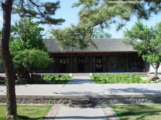
The Palace Pavilion in Jehol (Chengde) where Emperor Xianfeng died not long after signing a humiliating defeat at the hands of Foreign Invading Nations. (Photo: 2005)
China Report - Colonialism - Growth of Colonies & Japan after 1801 AD
A Map drawing of the Eurasian continent , parts of North-East Africa and the Middle East in the 19Th Century between 1801 AD and 1900 AD. Focal points are the expansion of western colonial posessions of Portugal, Britain and France, as well as Russia moving from West to East. Labeled seperately is the later Rise of the Empire of Japan in the East.
Included in this Map are the main cities across the continent with their brief histories and events during the 19Th Century. Marked in Colors for clarity are the various colonial and imperialist Nations. As relating to China; special attention is payed to so called Treaty Ports. The First Treaty Ports were forced open by Britain in the year 1841 AD, but counted over 80 in total by the end of the 19Th Century. The most important Treaty Ports in China are marked and described with a short history where the map allows.
1875 AD: Dungang / Hui Minorities are removed from the Hexi Corridor in Gansu and resettled in the South-West of the Province in order to prevent contact between the Muslim groups and the organization of future combined uprisings in the West ( Xinjiang ) and East ( Gansu , Ningxia , Shaanxi ) simultaneously.
1876-1879: a severe drought period lasting some three years causes devastating famines in northern China at the cost of an estimated 10 to 12 million lives.
1876: The China Inland Mission, which is emerging as one of the largest and most active (Protestant) Christian Missionary organizations in China, establishes a first mission in Shanxi Province . Francis James and Joshua J. Turner set up shop and start working to help those stricken by famine and disease. In the sam year Frederick W. Baller and George King are the first protestant missionaries to set up a Church in Shaanxi Province . Also in the same year George F. Easton and George Parker are the first missionaries to take up work in Gansu Province in western China along the Silk Road.
1877 AD: After George Smith briefly worked the Nimrud archeological site near Mosul (ancient Nineveh) in northern Iraq in 1873 and Hormudz Rassam returned there from 1877 to 1879. After his departure the Nimrud site was left untouched by scientists for almost 60 years (until a British School of Archaeology in Iraq team led by Max Mallowan resumed digging at Nimrud in 1949).
1877 : The name Silk Road, describing the network of trading routes across Central Asia is coined in 1877 by German geographer Ferdinand von Richthofen.
1877: French archeologist Ernest de Sarzec began excavations at Telloh (Lagash) in southern Mesopotamia (Iraq). Excavations lasted altogether some 14 years (1877-1901) uncovering in the process tablets written in cuneiform script and other ancient artifacts which, after dedicated study at western Universities, ultimately proved the historical existence of the Sumerian civilization and culture.
1878 AD: For the second time British Forces attacked Afghanistan . After defeating Afghan Forces at Peiwar Kotal, British Forces advance on Kabul taking the city with ease. However, in 1879 a massive Afghan uprising forced the British out of Kabul. Although the British manage to retake Kabul taking effective control of the entire country (territory) remains out of the question. In 1881, having installed a stooge ruler Abdur Rahman, British Forces withdraw from Afghanistan in 1881. The stooge rule of Abdur Rahman remained disputed by the brother of the deposed King Yakub Khan.
In the same year, 1878, Manchu Armies led by General Zuo-zong Tang complete their military campaign against Yakub Beg's rebellious Dzungar Islamic Forces in western Xinjiang, decisively defeating this rebellion and retaking most of the lost territories for the Manchu Qing Throne.
1878 AD: Jenny (Faulding) Taylor is first female Christian Missionary to travel in inland China. In 1878, having heard of the ongoing mysery of the Great North China Famine, she travels to Shanxi Province (with a female companion) in order to try help alleviate suffering. She establishes an orphanage in the city of Taiyuan , Capital of Shanxi Province .
May, 1880: Elizabeth (Annie) Wilson (Life: unknown - October 14, 1899), grand-daughter of British philanthropist Elizabeth Hanbury (life: June 9, 1793 - October 31, 1901), working for the China Inland Mission, becomes the first female protestant missionary to help spread the gospel in Gansu Province in western China. Elizabeth spent eight years working in- and around the small town of in Han-Chung and in Chinese Turkestan (Xinjiang), until illness forced her to return to England in 1888.
1881 AD: Russia withdraws from the Qing Dynasties territories in the Ili Valley (Today in Ili-Kazakh Autonomous Prefecture, Xinjiang Uyghur-Autonomous Region , China (P.R.C.)) which it had occupied since 1871. In Return for this "gesture" Russia receives 90 million rubles and the possession of other Qing Dynasty Territories in the nearby valley of the Irtysh River creating a local border arrangement which basically lasts to this day.
1881: First archeological excavations of he site of Mount Nemrut (Turkish: Nemrut Dağı; Kurdish: Çiyayê Nemrûdê ; Armenian: Նեմրութ լեռ), due to the presence of mysterious ancient statues on its top the suspected location of a 1st century AD. Royal Tomb, are done by Karl Sester, a German engineer assessing transport routes for the Ottomans. Although subsequent excavations have failed to reveal the tomb of King Antiochus, the site is nevertheless still believed to be the site of his burial.
1884: Russia completes the Trans-Urals railroad, which as its name suggests for the first time had a railway across the Urals Mountains from west to East.
1888: Death of the Russian Central Asia and Silk Road explorer, geographer and adventurer extraordinaire Prezhevalsky ((Russian: Никола́й Миха́йлович Пржева́льский)(Life: April 12 [O.S. March 31] 1839 - November 1 [O.S. October 20] 1888) at Karakol Town in Kyrgyzstan .
(Read More in: "History of Tashkent" ).
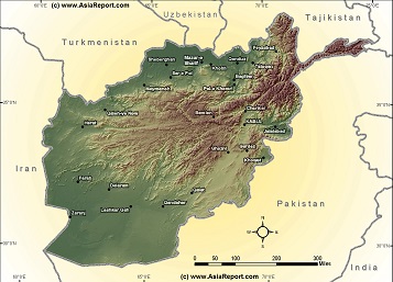
Asia Report - Schematic Relief Overview Map of Afghanistan and Cities
A simple schematic map overview Map of Afghanistan, delineating borders with adjoining Nations of Central Asia and depicting the rough locations of all cities within Afghanistan.
Map includes names of all Provincial Capital cities of Afghanistan and Provinces, relief of terrain.
Browse the map, navigate cities and click through for more information by location.
1839 AD: British Indian Forces attacked northward moving into Afghanistan . They take the Afghan Capital of Kabul while reporting of meeting only moderate resistance. After the fall of the Capital, the Afghan Emir and founder of the Barakzai Dynasty, Dost Muhammad (Pashto: دوست محمد خان) is deposed and replaced with a British Stooge ruler, Shuja Shah Durrani (deposed in 1809). The fallen Emir Dost Muhammad was exiled to Mussoori in north India.
1841: Afghan Forces led by Akhbar Khan rose against British occupation forces in the Afghan Capital City of Kabul, forcing the British Forces out of the city. British Forces surrender in November of 1841. They are promised a safe passage out of Afghan Territories.
1842 AD: British Forces who had previously invaded Afghanistan started their "retreat from Kabul". On January 13 of 1842 British soldiers and civilians who have been guaranteed a safe passage out are massacred by Afghan Forces at the Khyber Pass (which since remains notorious). Of the 16 thousand 500 refugees only a handful survive the ordeal. Later in the year a British spring and summer offensive brings British Forces to retake Kabul but by December of 1842, the British once more retreat back into northern India (Today: Pakistan). This final retreat ended what is today known as the "First Afghan-British War".
April 1842 AD: The British puppet ruler of Afghanistan, Shah Shuja` is murdered. In the aftermath the fallen Emir of Afghanistan, Dost Muhammad Is returned to Kabul with British consent in an attempt to restore the peace in the Afghan Capital of Kabul.
1842: The Dur-Sharrukin (Arabic: دور شروكين ; Fortress of Sargun) at Khorsabad was first noticed by Paul-Emille Botta, who at the time was the French Consul to Mosul (ancient Niniveh). Since Botta believed the ruins at Khorsabad to be the lost remains of the ancient Assyrian Capital of Niniveh, he excavated the site between 1842 and 1844, finding a considerable number of archeological treasures and relics.
1845 - 1847 AD: Excavations at the ruins of the ancient City of Nimrud near Mosul in northern Iraq were conducted by Austen Henry Layard. In 1849 he returns for a second archeological mission working on into 1951. Among things Layard found cuneiform scripts (carved in stone), however he was unable to come to a conclusion as to the exact nature and origins of the site. Following Layard's departure, the work was handed over to Hormuzd Rassam, himself an Assyrian, in 1853-54 and then W. K. Loftus in who excavated and studied the site in 1854-55.
1850 AD: Death of the Daoguang Emperor (Reign: 1821-1850), the 6th Emperor of the Manchu Empire.
1852: Archeological excavations at Khorsabad (Dur-Sharrukin) in northern Iraq are resumed by Victor Place and continue on to 1955.
1853-1854: The site of Tell El-MMuqayyar (Later proven to be the City of Ur) was first excavated, on behalf of the British Museum and with instructions from the Foreign Office, by John George Taylor, British vice consul at Basra in Iraq from 1851 to 1859. The Taylor archeological dig uncovered the Ziggurat of Ur and a structure with an arch later identified as part of the "Gate of Judgment".
1854 AD: Persia (Iran) lost the Syr River Basin to advancing Russian Forces which ended Persian influence in Central Asian territories.

June 1842 AD: Having languished for months in a local dungeon at Buchara (current day Uzbekistan , two British Officers are put to death in the large square in front of the Palace of the Emir. The two officers who are beheaded on orders of the Emir are Colonel Charles Stoddart and Captain Arthur Conolly, both of whom had been sent by the British East Company to the Buchara Khanate in order to win over the local Emir to their side in the developing "Great Game for Central Asia". Their attempts at forging an alliance between the Khanate and the British in India against the Russians failed, both end up paying the highest price. Their bodies are buried underneath the square in nameless graves which to this date remain unexcavated. Colonel Stoddart will be remembered as the first known person to cast the term of "Great Game in Asia".
1812 AD: A National census in China indicates a population of 340 million.
1824: The ancient silk road city of Herat in north western Afghanistan became independent for several years when the Afghan Empire was split between (Persian: هرات,Harât ,Herât; Pashto: هرات; Ancient Greek: Ἀλεξάνδρεια ἡ ἐν Ἀρίοις, Alexándreia hē en Aríois; Latin: Alexandria Ariorum) the competing Durrani Dynasty and Barakzai Dynasty.
1838 AD: Having laid claims to it's territory for years, the State of Persia (Iran) with diplomatic and material support from Russia invades and lays siege to the city of Herat in north western Afghanistan. The siege fails and British diplomatic and military pressure (gunboat diplomacy in the Persian Gulf) forces the Persians to withdraw from the city.
1884: The British invasion of Herat (following the Russian take over in much of Central Asia), shortly afterwards followed by the destruction of the 15th century Islamic Musallah complex (also Musalla of Gawhar Shad) in Herat. The officially stated reason was to get a good line of sight for their artillery against Russian invaders who however never came.
1820 AD: The ancient silk road city of Merv (Turkmen: Merw, Мерв, مرو; Persian: مرو, Marv)(formerly Achaemenid Persian Satrapy of Margiana, and later Alexandria (Margiana) (Ἀλεξάνδρεια) and Antiochia in Margiana (Greek: Ἀντιόχεια τῆς Μαργιανῆς)) becomes a part of the Khiva Khanate (Uzbek: خیوه خانلیگی, translit. Xiva xonligi, Persian: خانات خیوه)(current day Turkmenistan).
1807 AD: Having been victorious on battlefields across Europe, French Emperor Napoleon Bonaparte proposes to Tzar Alexander I of Russia a joint operation to invade India through Central Asian pathways in order to wrest that sub-continent from British domination. In later communications Napoleon communicates to Tzar Alexander I that after success on the battlefield the Indian sub-Continent may be divided between the French and the Russians. When received in London, the news causes great alarm in Government circles and at the The East Asian Company. The proposals, although practically far fetched will create the beginning of a long period of International competition for influence in Central Asia which will play out in the 19th and 20th centuries.
1839 AD: In the fall of 1839 General Vasily Perovsky set out from Orenburg with 5,000 men supported by some 10 thousand camels in order to conquer the city and Khanate of Khiva. However, the advancing army met an unusually cold winter, lost most of his camels, and was forced to turn back after going halfway and suffering heavy losses. Although the campaign failed dismally, news of its occurrence and failure did move the opposing British to a forward policy leading to the subsequent British invasion of Afghanistan, intended to ward of dangers of Russian moves on India via Central Asia and Afghanistan.
1832 AD:The British political officer, diplomat and explorer Captain Sir Alexander Burnes (Life: 16 May 1805 - 2 November 1841) travels to Bochara (current day Uzbekistan) to reach that city on June 27, 1832 AD. Having stayed in Bokhara for a considerable time, his party then traveled onwards through the Khiva Khanate to reach Merv (current day Turkmenistan). The intended ultimate destination of the journey was the city of Khiva, however warned of impending risks to his person and mission Burnes eventually decided to travel through to Astrabad (استرآباد)(Today: Golestan Province, Iran) and from there to the Persian Gulf for a passage back to his homebase in India, airing back in Bombay on January 18, 1833. The mission was considered a great diplomatic success, also gathering valuable intelligence for the British side, making Burnes famous as "Bokhara Burnes".
1884: The ethnically Polish and Lithuanian born Tsarist Russian lieutenant Bronislav Gronbchevskiy (Б. Л. Гронбчевский)(alternative spellings Grombchevskiy and Gromchevskiy) makes a journey into "Kashgaria" visiting, surveying and mapping Kashgar, Yengisar (Yangi Hissar), Hunza, Yarkand and Khotan. Sometimes afterward a secret report counting 249 pages was completed and printed in the then Russian held town of Marghilan (Uzbek: Marg‘ilon / Марғилон; Russian: Маргилан) in the Fergana Valley (of current day Eastern Uzbekistan). The report (Otchet’’ o poezdke v’’ Kashgar’’ i yuzhnuyu Kashgariyu v’’ 1885 godu: starshago chinovnika osobyx’’ porucheniy nri voennom’’ gubernatore Ferganskoy oblastiporuchika B. L. Gronbchevskago) is a survey of topography, infrastructures, fortifications and other military arrangements as well as public administration in the Chinese Kashgaria province. British agents and their activities in the region are commented on at some length, and special attention is drawn to the Khanate of Kunjut (Hunza), situated on the southern slopes of the Hindu Kush Mountain Range and considered by the author to be of strategic importance for the Russian Empire.
1807 AD: Completion of the historic Chor Minor (Char Minar, Uzbek: Chor minor), alternatively known as the Madrasah of Khalif Niyaz-kul Mosque in Buchara (Bokhara) in current day Uzbekistan. In Persian, the name of the monument means "Four minarets", and the building indeed has four towers which are however not really minarets as three of them were used for storage, and one has a staircase leading to the top floor. All of the towers are however topped by domes covered by blue ceramic tiles making them appear like minarets. The structure was built by Khalif Niyaz-kul, a wealthy Bukharan of Turkmen origin in the 19th century under the rule of the Janid dynasty. It was originally part of a larger complex which functioned as a Madrasah (religious school), however only the Chor Minor remains today. Today the building is protected as a cultural heritage monument, and also it is a part of the World Heritage Site Historic Centre of Bukhara.
1818: In the early 19th century Pope Pius VII was the first to heed to modern idea's of urban preservation originating early forms of urban planning. After 1802 large scale preservation works started on the Forum Romanum and other remnants of Roman Heritage beginning with the famous Colloseum. As inscribed on a plaquette facing the Forum Romanum in Rome, in 1818 Pope Pius VII (Papacy: 14 March 1800 AD - 20 August 1823 AD) commissioned the architects Raffaele Stern (1774 - 1820) and Giuseppe Valadier (1762 - 1839) to restore the pillars of the Arch of Titus which had been damaged by the creation of a little room inside the archway. In 1818, Stern began the restoration of the Arch of Titus which was completed in 1824 by Valadier.
1893-94: the Buchara Emirate, which had been made a vassal state of Russia in 1873, grants the Russians the right to build a fortress at Pattakesar village near Termez (on the border with current day Afghanistan). The Fortress becomes Russia's main garrison and a military border fortification on the Afghan Border and a port on the Amu Darya river port was built there soon afterwards.
1888: Russian troops complete the construction and opening of the first (wooden) bridge across the Oxus (Amu Darya) between Termez in Uzbekistan and Hairatan in the northern Balkh Province of Afghanistan. This first wooden bridge was built under the supervision of the Russian tsarist army general M. Annenkov, when Russia was just starting to develop Central Asia. At that time the construction of the Trans-Caspian Railway was underway and a crossing means across the Amu Darya was badly needed. (Later in 1902 a railway bridge was added. It however served only a short time due to natural erosion.)
China
Asia
Chat
Features :
History Great Wall
1811 AD: Following an initial influx of western visitors to the site of Babylon (comes from Greek Babylṓn (Βαβυλών), a transliteration of the Akkadian Bābilim (cuneiform: 𒆍𒀭𒊏𒆠)) in the 18 Century and subsequent trading interest of antiques by the British East India Company in the 1790's, Claudius Rich (Life: March 28, 1787 - October 5, 1820), a British Trade Agent, traveller and antiquarian working for the East India Company in Baghdad, undertakes the first known (non scientific) western excavations at the ruined ancient city of Babylon in 1811-12 and returned again in 1817. The results of his work at Babylon appeared first in the Vienna serial "Mines de l'orient", and in 1839 in London under the title "Narrative of a Journey to the Site of Babylon in 1811". After his two excavations at Babylon, Rich extended his travels to visit various places across Persia among them the Chaldean villages in the north of present-day Iraq, from Bagdad north to Sulaimaniya, eastward to Sinna, then west to Nineveh, and thence down the Tigris to Bagdad. He also traveled to Basra, Shriraz, ancient Persepolis, Mosul, ancient Niniveh and again Shirza where he died in 1820 after contracting cholera.
April 12, 1802 AD: The historic Sioni Cathedral of the Dormition in Tbilisi, Capital of Georgia, seat of the Georgian Orthox Christian Patriarch, became the scene of where the annexation of Georgia into the Russian Empire was announced. On that date, General Karl von Knorring, Russian commander in chief in Georgia, presented the manifesto to the assembled Georgian nobility and required the nobles to take an oath to the Russian Imperial crown. Those who refused were arrested.
1886 AD: Through the works of the geographer Sir Thomas Holdich (1843 AD - 1929 AD) who reported its existence in the year 1886 while working for the Afghan Boundary Commission (1884 - 86), the splendid Minaret of Jam near the town of Jam in the Shahrak (Persian: شهرک) District, of Ghor (Pashto/Persian: غور ; also spelled Ghowr or Ghur) Province in Afghanistan becomes known to the outside world. Having been constructed during the reign period of Sultan Ghiyas ud-Din (1157 AD - 1202 AD) at around the year 1190 AD and having seen the city of Firuzkuh destroyed around it by the Mongols in 1222 AD, the Minaret of Jam has stood in solitude along the Herat River (Hari-rud) lost and forgotten by the outside world for some 8 centuries. Since 2002 it is a world renowned UNESCO world cultural heritage site which however remains severely threatened by natural erosion, illegal excavations and ongoing conflict in Afghanistan.
1812 AD: A three story bell tower was built across the street (Sioni Street) from the cathedral Sioni church of the Dormition (Georgian: სიონი (ტაძარი)) the home church of the Orthodox Christian Patriarchy in Tbilisi, Georgia. The bell tower commemorates the Russian victory in the Russo-Turkish War of 1806 to 1812 .
December 18, 1878 AD: Birth of Joseph Stalin as Loseb Besarionis dze Jughashvili (Iosif Jugashvili)(Life: December 18, 1878 - March 5, 1953) in Gori (Georgian: გორი)(Today: regional capital of Shida Kartli), Georgia, in the Caucasus Region, then a part of the Russian Empire. In life he would go on to be a revolutionary and subsequently the extremely brutal dictator of the Soviet Union (U.S.S.R.) under the name Joseph Stalin (Joseph Vissarionovich Dzhugashvili Stalin). He ruled the Soviet Union from the mid-1920s until his death in 1953 with an iron fist, remaining a notorious historical figure to this day.
1843 AD: Start of construction of the Dolmabahçe Palace (Turkish: Dolmabahçe Sarayı) along the European side of the Bosphorus in Istanbul, Capital of the Ottoman Empire. The construction of the Palace was ordered by the Empire's 31st Sultan, Abdülmecid I (Ottoman Turkish: عبد المجيد اول Abdülmecîd-i evvel)(also known as Tanzimatçı Sultan Abdülmecid ; Sultan Abdülmecid the Reorganizer))(Life: April 23/25, 1823 - June 25, 1861)) as a replacement for the medieval Topkapı Palace (Turkish: Topkapı Sarayı ; Ottoman Turkish: طوپقپو سرايى, Ṭopḳapu Sarāyı), the former Royal Palace which was considered old fashioned and no longer up to modern standards or comparable to the palaces of mainland European Royals. The new modern palace was built near the site of the former Beşiktaş Sahil Palace, which was demolished. Hacı Said Ağa was responsible for the construction works, while the project was realized by Paris-schooled architects Garabet Balyan, his son Nigoğayos Balyan and Evanis Kalfa (members of the Armenian Balyan family of
Youtube Video: Istanbul's Dolmabahçe (Royal) Palace, now a National Museum of the Republic of Turkey.
Ottoman court architects). Construction of the immensely expensive palace would last until the year 1856. The Dolmabahçe palace was home to six Sultans from 1856, when it was first inhabited, up until the abolition of the Caliphate in 1924 (Between 1887 and 1909 Yıldız Palace was used in the interim). The last royal to live here was Caliph Abdülmecid Efendi. Mustafa Kemal Atatürk, the founder and first President of the Republic of Turkey, used the palace as a presidential residence during the summers.
1880: Start of the construction of the current day Yıldız Palace (Turkish: Yıldız Sarayı), situated in the Beşiktaş district of Istanbul on the European side of the Bosphorus strait. Although the Dolmabahçe Palace (Turkish: Dolmabahçe Saray) in the Beşiktaş district served as the official and very opulent Royal Palace of the Ottoman rulers, it was situated on the water front and therefor vulnerable to a waterborne attack. In fear of such an attack by the Russian Empire, which declared war in the year 1887, Sultan Abdülhamid II (Ottoman Turkish: عبد الحميد ثانی, `Abdü’l-Ḥamīd-i sânî; Turkish: İkinci Abdülhamit)(Life: September 21, 1842 - February 10, 1918)(also popularly known as Red Sultan or Abdul the Damned) decided to leave the Dolmabahçe Palace and have a new residence furnished for his residence. Thus, the Yıldız Palace, already a Royal Residence since the the reign of Sultan Ahmed I (1603 - 1617) in the 17th century, was reconstructed and considerably expanded, t become the official Royal Residence in the period 1887 to 1909 (There after, under the rule of Mehmed V, and until 1924 the Dolmabahçe Palace once more served as Royal Residence. Thus, although the Ottoman Empire had been factually bankrupted by the previous Sultan's and particularly the construction of the Dolmabahçe Palace, the renowned Italian architect Raimondo D'Aronco was asked to expand the Yıldız Palace and to build new buildings to the palace complex. Construction took place in various phases with additions added in 1889 and 1898. Ultimately, when Abdülhamid II moved there, the palace became the fourth seat of Ottoman government (the previous ones were the Eski Saray Old Palace in Edirne, and the Topkapı Palace and Dolmabahçe Palaces in Istanbul). Government officials working for Abdülhamid II had their offices in this building and the Palace also had sections for prisoners. After the Ottoman Empire ended, the palace was used as a luxury casino before being converted into a guest house for visiting heads of state and royalty. Today it is a (Royal Palace) museum and its gardens can be used for private receptions, such as the Istanbul Antiques Fair at the Silahhane (Armoury) Hall, which usually takes place in November. The Istanbul office of the OIC (Organisation of Islamic Cooperation (OIC; Arabic: منظمة التعاون الإسلامي; French: Organisation de la coopération islamique) is also located within the Yıldız Palace.
Youtube Video: Biography of leader of the Soviet Union Joseph Stalin (For All Documentary).
/asiareport/images/ElizabethAnnieWilson-ChinaInlandMission-1880-1888-01-ID-351ef68f-2c33-47c3-9b64-537bed7f1708.png)
The Elizabeth Annie Wilson in China. (Photo: unknown date between 1880 and 1888).
1870 - 1873: George Kennan, an American explorer who had earlier traveled in Russian Siberia and explored the wilderness of Kamchatka Peninsula for two years, travels to the Caucasus Region. During 1870, on friendly terms with the Russian Tsarist regime, he returned to St. Petersburg and travelled to Dagestan, in the northern Caucasus region, which had been annexed by the Russian Empire only ten years previously. There, he became the first American to explore its highlands, a remote Muslim region of herders, silversmiths, carpet-weavers and other craftsmen. He travelled onward through the northern Caucasus area, stopping in Samashki and Grozny (current day Capital of Chechnya), before returning once more to America in 1871. These travels earned him a reputation as an "expert" on all matters pertaining to Russia, a reputation on which he further built his career as journalist, war correspondent, writer and lecturer.
1888: As early as in the year 1888, Russian doctor and traveler Nicolay Lvovich Zeland suggested that the mysterious stone complex of Tash Rabat in current day Bashy district, Naryn Province, Kyrgyzstan near the Torugart Pass (Chinese: 吐尔尕特山口; Kyrgyz: Торугарт; Russian: Перевал Торугарт)) and the border with the Xinjiang-Uyghur Autnomous Region of the Peoples Republic of China, was a Nestorian or Buddhist monastery by its origins. Today it is held to originally have been a Nestorian Church built in the 10th century AD which was converted to the use of caravanserai at some time in the 15th century. Today, the Tash Rabat is a popular albeit ultra-remote tourist destination of the silk road in the Tianshan Mountains in the extreme south of Kyrgyzstan and registered as the largest ancient stone construction within Central Asia. The (restored) structure consists of 31 rooms, including chambers in the central hall. The rooms are dome-shaped; transition from a quadrangular frame to a dome is done using a squinch. Tash Rabat is completely made of crushed stone on clay mortar with gypsum mortar sealing joints. Between the 15th and early 20th century it served a a caravanserai, i.e. a stop over point for travelers and merchants and their livestock on the silk road.
1854 AD: The Russian explorer of Kazakh birth Chokan Valikhanov (also Shoqan Walikhanov)(Shoqan Shynghysuly Walikhanov (Kazakh: Шоқан Шыңғысұлы Уәлихан, Shoqan Shynghysuly Walikhan; Russian: Чокан Чингисович Валиханов)), who had made his first expedition to the region of Issyq Kölwas (Issiq Kul Lake) in 1855-56, became the first person to provide a description of the mysterious stone complex of Tash Rabat in the south of current day Kyrgyzstan to reach a western audience. Among things his reports suggested that the structure was linked to the frontier of the ancient settlement of Osh (current Kyrgyzstan).
June 28, 1858 AD: Russian explorer, scholar and ethnographer, and talented folklorist of Kazakh birth, Chokan Valikhanov (also Shoqan Walikhanov)(Shoqan Shynghysuly Walikhanov (Kazakh: Шоқан Шыңғысұлы Уәлихан, Shoqan Shynghysuly Walikhan; Russian: Чокан Чингисович Валиханов)), who had made his first expedition to the region of Issyq Kölwas (Issiq Kul Lake) in 1855-56, launches his second expediation along the Silk Road in Central Asia. Serving as a decoy to the geo-political intentions of the mission serving Russian interest in the "Great Game in Asia", Walikhanov embarked with a caravan of 43 men, 101 camels and 65 horses. Following his successful passage through current day Kyrgyzstan, the Tianshan Mountains and the Chinese border without suspicion, the caravan arrived in Kashgar in early October of 1858. Over the course of a half-year, Walikhanov took meticulous notes regarding major towns, including maps, the goods in the bazaars, the languages spoken and the customs practiced. Due to local suspicions of the real strategic intentions of the Russians in the region, the expedition was forced to cut short its plans and the caravan left Kashgar in April 1859 in order to return to Russia and file his report. The expedition was to be Valikhanov's last such venture as he later contracted tuberculosis while in St. Petersburg and never quite recovred his health and fitness for such duties.
April 10, 1865 AD: Death of silk road explorer, scholar and ethnographer, and talented folklorist of Kazakh birth, Chokan Valikhanov (also Shoqan Walikhanov)(Shoqan Shynghysuly Walikhanov (Kazakh: Шоқан Шыңғысұлы Уәлихан, Shoqan Shynghysuly Walikhan; Russian: Чокан Чингисович Валиханов)) at age 29. Following his two expeditions in Central Asia in 1855-56 and 1858-59, Valikhanov had contracted tuberculosis in 1861 leaving him unfit for military duties and expeditions on the silk road. There after, serving various functions for the Russian cause he published various books, among them "Traces of Shamanism among the Kazakhs", "Regarding the camps of Kazakh nomads", "The Kazakhs" and finally "Chinese Turkestan and Dzungaria' Walikhanov and other Russian travellers, The Russians in Central Asia", which was published in London, by Edward Stanford in 1865. In addition, Walikhanov also compiled epic poetry, including "Kozy-Korpesh - Bayan-Sulu", as well as what he called the Iliad of the Steppe, the Epic of Manas. Valikhanov spend his last months in the village of Sultan Tezek, on the Ili River north of Vernoe (current day Almaty (Kazakh: Алматы, translit. Almaty ; Russian: Алматы)(Formerly Alma Ata (Russian: Алма-Ата); formerly Verny (Russian: Верный Vernyy)). With Walikhanov a National Hero in Kazakhstan, there is a statue of Walikhanov and Dostoevsky in the city of Semey (Kazakh: Семей, translit. Semeı; Russian: Семей)(Formerly Semipalatinsk (Kazakh: Semıpalatinsk, Russian: Семипалатинск)), Kazakhstan, near the local Dostoevsky museum.
Youtube Video: Tash Rabat stone silk road complex in Naryn Province, Kyrgyzstan, by drone in 2018 with Umar Li.
1856 AD: The Russian geographer and later head of the Russian Geographic Society (from 1873 until his death) Pyotr Petrovich Semyonov-Tyan-Shansky (Russian: Пётр Петрович Семёнов-Тян-Шанский)(Life: January 2 (New style: January 14), 1827 - February 26 (New style: March 11), 1914) departs on his tour of exploration in Central Asia. He set off from Barnaul on his first
of two expeditions, passing through the Altay Mountains and visiting Lake Issyk Kul on his way. In 1857, he returned to the Tian Shan, exploring the interior of this hitherto unknown mountain range. Semenov was the first European to see the scenic panorama of the Tengri Tag, and its most beautiful peak, the colossal Khan Tengri. On his expedition Petrovich disproves Humboldt's earlier claims about Tian Shan's supposed volcanic origins. In 1858, the year after his expedition, he published the first systematic description of the Tian Shan. Half a century after the facts, Russia's last ruling Monarch, Tzar Nicholas II of Russia (Russian: Николай II Алекса́ндрович, tr. Nikolai II Aleksandrovich)(Life: May 18 [O.S. 6 May] 1868 - July 17, 1918) authorized him to add the epithet "Tian-Shansky" (that is, "of Tian Shan") to his last name.
1888 - 1889: In 1888 and 1889 Andrey Petrovich Semyonov-Tyan-Shansky (Russian: Андре́й Петро́вич Семёнов-Тянь-Ша́нский) (Life: St. Petersburg June 9 (21), 1866 - Leningrad April 8, 1942), son of the Tianshan geologist explorer and later head of the Russian Geographic Society Pyotr Petrovich Semyonov-Tyan-Shansky (Russian: Пётр Петрович Семёнов-Тян-Шанский), traveled to the Trans-Caspian Regions and throughout the Turkestan regions (current day Turkmenistan, Uzbekistan, Tajikistan and possibly parts of Kyrgyzstan) in search of insects. At some point afterwards, Andrey Pyotr Semyonov then published a book about his traveling adventures entitled "Travels in the Tian'-Shan' 1856-1857", which was later in 1898 also published in the west in a translated form (Semenov, Petr Petrovitch. Travels in the Tian'-Shan' 1856-1857. Trans. by Liudmila Gilmour, Colin Thomas and Marcus Wheeler. Edited and annotated by Colin Thomas. The Hakluyt Society, London. (1998). ISBN 0-904180-60-3). Having explored these regions under Russian overlordship, he then in 1890 became a curator at the Imperial Academy of Sciences. In this function, He processed large collections of beetles and weevils belonging to the entomological society and museum, including the collections of N. M. Przheval’skü, G. N. Potanin, P. K. Kozlov, and P. P. Semenov-Tian-Shanskii. Semenov-Tian-Shanskii’schief works dealt with the taxonomy and zoogeography of insects and the theory of species. He also translated poems by the Roman lyrical poet Horace.
1829 AD: The monk Iakinf Bichurin (officially: Nikita Yakovlevich Bichurin (Никита Яковлевич Бичурин)(Life: August 29, 1777 - May 11, 1853), better known under his monastic name Hyacinth (name as archimandrite and Church leader), or Iakinf (Иакинф)(as tonsured a monk since 1800 AD)), who was one of the founding fathers of Synology and the ninth leader (Archimandrite) of the Russian Orthodox Mission to Beijing, China (1807 - 1821)(both an outpost of Orthodoxy and the Embassy of Russia to China), proposed the idea for the name East Turkestan to replace the term "Chinese Turkestan" (for the current day Xinjiang-Uyghur Autonomous Region of the Peoples Republic of China) in his book "Descriptions of Dzungaria and East Turkestan" ( published in 1829). Today he is still hailed as having been the first Russian synologist. His remains are buried at Lazarev's Cemetery, Alexander Nevsky Lavra (Saint Alexander Nevsky Monastery) in Saint Petersburg.
/asiareport/images/Lakinf-Hyacint-Bichurin-1807-1821-01-ID-b176b354-dcee-4e32-a4e0-6851274465d9.jpg)
A painted portrai of Lakinf Hyacint Bichurin, first Russian synologist and Ninth leader of the Russian Christian Orthodox Church in Beijing China (1807 - 1821).
1837 AD: January 1, The Levant is struck by the Galilee earthquake of 1837, often called the Safed earthquake. A assessment done in 1977 had the epicenter just north of the city of Safed ((Hebrew: צְפַת Tsfat, Ashkenazi: Tzfas, Biblical: Ṣǝp̄aṯ; Arabic: صفد, Ṣafad), a city in the Northern District of Israel) and the magnitude at 6.25 - 6.5 on the Richter Scale, but in 1997 seismologist Nicholas Ambraseys argued that the event may have been more substantial. In the event the city of Beirut was rattled collapsing houses and the cities of Sidon (also Sayda (Arabic: صيدا)) and Tryre (Arabic: صور Ṣūr; Phoenician: 𐤑𐤓 Ṣūr; Syriac-Aramaic: ܣܘܪ, Hebrew: צוֹר Tzór; Greek: Τύρος Týros; Latin: Tyrus; Armenian: Տիր Tir; French: Tyr) were heavily damaged. In addition, the city of Tiberias (Hebrew: טְבֶרְיָה, Tverya, (audio) (help·info); Arabic: طبرية, Ṭabariyyah) on the western shore of the Sea of Galilee and surrounding villages were heavily damaged with great loss of life. Reportedly, the abandoned Crusader Castle Château Pèlerin ((Latin: Castrum Perigrinorum, French: Château Pèlerin, Italian: Castello Pelegrino), also Atlit fortress and Pilgrim's Castle) today situated about 13 kilometres (8.1 mi) south of Haifa on the northern coast of Israel sustained severe damage.
March 18, 1838 AD: During a journey north and eastwards out of Kunduz (Today: Capital of Kunduz Province, northern Afghanistan) which was part of a larger overall mission to find the source of the Oxus River (Amu Darya) , Captain John Wood (Life: 1812 - November 14, 1871) accompanied by with Dr Perceval Lord reached Ai-Khanoum (Aï Khānum, also Ay Khanum, lit. “Lady Moon” in Uzbek) where, he was informed by local inhabitants, “an ancient city called Barbarrah” had stood. During the visit Captain Wood could make out the outlines of ancient city walls, however at the time only a small Uzbek village occupied the site within the walls. Wood did inquire about possible ancient coins or reis that had been recovered, however (according to his account) upon his so doing, he was laughed at by the local villagers. With this, the site was (re-) discovered for the western world and its scientists, however little or no clues as to its true origins were gained, thus leading to failure of recognition of the sites ultimate historic importance. Although an account was written in the book of the travels of John Wood in 1972 (Captain John Wood, "Journey to the Source of the River Oxus", John Murray Publishers, London, 1872), the site was nevertheless left forgotten by the world until the year 1926 when the French orientalist Jules Barthoux set off on a tour of northern Afghanistan in search of promising sites for investigation. More than a century later archeologists would conceive of the idea that the Ai-Khanoum site may have been the location of the ancient city of Alexandria on the Oxus, which is supposed to have been founded by Alexander the Great and his armies in the year 329 BC when they reached and crossed the Oxus River.